4WARN Blog: Spring fling!

Wow… beautiful blues skies will greet you this Wednesday afternoon!

CAMERA

After a very cold start to the day this morning, we’re warming up to the mid-60s thanks to lots of sunshine!  Expect those 60 degree temps to carry into tonight… and as the sun sets, cooling off to the 50s.

Day Planner Noon

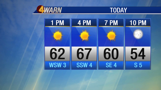
Overnight lows will drop to the mid-40s… so not as cold as we were last night.

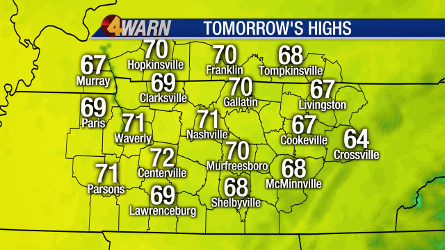
By tomorrow– it gets even better!  Definitely feeling the springtime weather with high temperatures reaching the 70s for many.

iCAST TomorrowsHighs

The 70s will carry into Friday, as well.  But the clear blue skies won’t stick around that long.  By late Thursday night into Friday morning, clouds will begin building back into the midstate… eventually bringing some spotty showers Friday morning into the afternoon.

The rain chances really ramp up as we head into Saturday. Thunderstorms are possible. As of now, it doesn’t look like any severe weather for Nashville, but these storms could pick up in intensity throughout the day.  It looks like the main threats will be hail and strong gusty wind.

Rain Chance GRAPH_Days

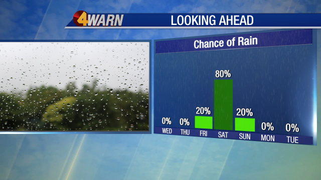
Rain moves out Sunday morning– that will be the drier half of the weekend…. but much cooler!  Temperatures will go from being in the 70s on Saturday… to the 50s on Sunday.  That cooler weather will hang around for the start of the work week.

Be sure to catch Meteorologist Dan Thomas on News4 at 4, 5, 6 and 10 P.M.  He will be in for Lisa Spencer tonight.  Stay with News4 on-air, online, and on the News4 Weather app for your smartphone or tablet for weather updates.

-Meteorologist Melanie Layden

Posted in Uncategorized | Comments Off on 4WARN Blog: Spring fling!

4 Things to Know About Our Weather

There are 4 things you should know about our upcoming weather.  They are…

1)  The rain showers are nearly done for tonight.

After spotty showers off and on all afternoon, the rain’s gradually coming to an end.  Today’s rain was triggered by warmth created by the sun interacting with some relatively cold air in the upper atmosphere.  SO, after sunset around 7:30pm, the showers will continue to fizzle.

What that means is if you’ll be out late tonight or if you work overnight, you won’t have to be concerned about getting rained on.

VIDEO LYNX.png

2)  Humidity will drop noticeably tomorrow.

While today was cooler than yesterday, it wasn’t much less humid.  Notice dew points as of 6pm still reflected the mugginess outdoors.  They were generally around 70.

DMA Dew Points.png

Tomorrow afternoon, as a northwesterly breeze sets up, much crisper air will begin filtering into Middle Tennessee.

3)  Tomorrow & Thursday evenings will be the nicest we’ve had in months.

Be sure to make plans to spend a little time outdoors either Wednesday or Thursday evenings.  They’ll be the nicest we’ve had in months with temperatures in the 70s and lower humidity.  This change will be thanks to a double barrel core of high pressure moving our way.  Enjoy!

SATRAD_3D

4)  Thursday morning will actually feel a bit chilly!

Take a look at low temperatures for Thursday morning.  Many kids will want a jacket at the bus stop.  If you step out to walk the dog before going to work, you’ll notice the chill in the air, as well!

iCAST Temps_OneTime

Watch Lisa Spencer tonight on News4 at 10pm.  She’ll track the leading edge of lower humidity headed our way.

DT

Posted in Uncategorized | Comments Off on 4 Things to Know About Our Weather

4WARN Weather Alert: Evening Severe Storm Threat

Strong-severe thunderstorms will be possible this evening, especially over western sections of Middle Tennessee and in southwest Kentucky.

Outdoors as of 6:30pm, scattered thunderstorms continue to slide eastward along the Cumberland Plateau.  A Severe Thunderstorm Watch is in effect over our western counties however, until midnight.

VIDEO LYNX.png

Notice the bands of organized strong-severe thunderstorms approaching from the west.  West Tennessee and eastern Arkansas have very active weather now.

SATRAD_3D

These storms will pass through a warm and unstable airmass over the Mid State this evening, so they’ll they’ll stay potent for several hours.

DMA Temps_Renaissance

While the severe threat is highest west of Nashville this evening, a few strong storms could move into Nashville later tonight.  Marginal risk is the least significant, while an enhanced threat reflects the greatest severe potential for tonight.

SEVERERisk_DMAOnly

Storms will be most likely in the Mid State between 7pm and 1am.  Damaging wind gusts will be the primary threat.

SEVERE THREAT

Here’s a look at FUTURECAST.  Notice some of the most intense storms should parallel the TN/AL line this evening.  Very powerful thunderstorms are also likely during the mid evening over southwest Kentucky.

Be sure to keep tabs on the weather with Lisa Spencer this evening.  She’ll provide live updates as needed on News4, social media, and on News4 at 10pm later tonight.

DT

Posted in Uncategorized | Comments Off on 4WARN Weather Alert: Evening Severe Storm Threat

Stormy Start to the Week….Then Paradise

We’ll have a stormy start to this week.  Then….paradise!

Today’s starting mostly cloudy for many with spotty dense fog.  Notice the fog is most widespread over West Tennessee and eastern Middle Tennessee.

VIDEO LYNX

A Dense Fog Advisory remains in effect for West Tennessee until 9am.

WATCHWARN_1.png

Temperatures are similar to this time yesterday — around 70.

DMA Temps_Servpro

Fog will burn off by 9am.  Then the sky will become partly cloudy.  Temperatures will soar to around 90.  Isolated showers will form, too, but we won’t have the widespread heavy downpours we had yesterday.

Here’s a look at highs this afternoon.

iCAST TodaysHighs

Notice the weather system over the Plains?  That’s headed our way for tomorrow and tomorrow night especially.

SATRAD_3D.png

A few storms that develop tomorrow afternoon and evening could even produce damaging wind gusts.  For this to happen though, we’ll need several hours of sunshine to heat up the atmosphere.

SEVERERisk_DMAOnly

FUTURECAST shows how the weather will transpire in our area late tomorrow, into Tuesday.

Tuesday will be a little cooler.  Wednesday and Thursday will be absolutely gorgeous will autumnlike humidity and below average temperatures.  Then, more typical late summer weather will return on Friday and Saturday.

7 Day AM

Watch News4 later today at 5pm.  Cody Murphy will update you on any showers passing through our area.

DT

Posted in Uncategorized | Comments Off on Stormy Start to the Week….Then Paradise

Unsettled Weekend But Don’t Cancel Your Outdoor Plans

It’s going to be an unsettled weekend, but don’t cancel your outdoor plans.  It’ll rain at times in spots, but most of the day will be dry for any one given neighborhood.

As of 9am today, widespread rain was sliding through eastern Middle Tennessee.  Take a look on Real Time Red Radar.

VIDEO LYNX

Temperatures were mainly in the 70s, although some spots were nudging 80.

DMA Temps_NoSponsor

It was very muggy too!

DMA Dew Points

Notice that clouds were winning out in most spots.  Today’s going to be one of those variably cloudy days.  At times it’ll be bright, at other times it’ll look like it’s about to rain, and at other times it’ll actuallly be raining.

VIDEO LYNX2

FUTURECAST shows how today will progress.  Notice how showers and storms will become numerous along a line that marks a weak cold front sliding into our area.  Behind that front, rain will be less widespread tomorrow.

Highs this afternoon will be in the mid-upper 80s.

iCAST TodaysHighs

Weather for the Titans home preseason game should be pleasant this evening.  Showers will be diminishing through the game.  There’s even a realistic chance showers will completely avoid Nissan Stadium during game time.  Keep your fingers crossed!

EVENT 3Temp

Tomorrow, highs will be a degree or two higher in spots with a little more sunshine.

iCAST TomorrowsHighs

FUTURECAST for tomorrow shows just isolated showers and thunderstorms after widespread low clouds and patchy dense fog dissipate.

Monday and Tuesday of this coming week will be unsettled with more showers and storms.  Then, behind a stronger cold front, humidity and temperatures will drop to early autumnlike levels on Wednesday and Thursday.

7 Day AM

Watch Cody Murphy later today on News4 at 5pm.  He’ll show you where any thunderstorms in our area are and where they’re headed next.

DT

Posted in Uncategorized | Comments Off on Unsettled Weekend But Don’t Cancel Your Outdoor Plans

August 16: Unsettled Pattern

On and off rain and thunderstorms expected through the weekend.  The good news…we will get some needed rain and the good news…it won’t be a wash out this weekend. And for more good news, we will get a break from the excessive heat.  Yesterday the high reached 95°, today most spots will peak in the upper 90s.

Some of the storms this afternoon into the evening could be strong to severe. Middle Tennessee is in a marginal risk area for severe storms. Marginal is a one on the 1 to 5 scale.

SEVERERisk_DMAOnly.png

The greatest threat is possible damaging wind of 60 mph or greater.  Some storms could also produce heavy downpours and there is also a lot of lightning likely.

Here is the latest Futurecast timeline on the storms. Keep in mind this is just the depiction from the RPM model, some of the other models are showing more widespread rain coverage. That would not be good for outdoor events tonight like Live on the Green.  Be prepared.

FutCAST RPM4km SATRAD1FutCAST RPM4km SATRAD2FutCAST RPM4km SATRAD3FutCAST RPM4km SATRAD4FutCAST RPM4km SATRAD5

Again tomorrow more rain and storms are possible.  The storms do have the potential to be severe, so Middle Tennessee is again in a Marginal Risk zone for severe weather.

Scattered showers and storms are likely Saturday and Sunday with highs in the upper 80s. It won’t rain all day each day, more scattered in nature.  Sunday will be the drier of the two days.

2018 4DAY UBER.png

Rain is a good thing. Many areas in Middle Tennessee are very dry.  The Drought Monitor indicates in yellow spots that are “Abnormally Dry.

DROUGHT MONITOR.png

Cody Murphy is filling in for me this afternoon and he’ll have an update.

Lisa Spencer


Posted in Uncategorized | Comments Off on August 16: Unsettled Pattern

Unsettled weather pattern begins Thursday

It has been a dry last few days across Middle Tennessee but a change in scenery is on the way beginning Thursday.

Thursday will mark the start of an unsettled weather pattern across the Mid-State.
Widespread showers and storms are in the forecast Thursday all the way through the weekend and even into next week.
If it seems the rain has been dodging your yard, well hopefully you’ll see some rain at some point in the next week.
Here’s a timeline on when we’ll see showers Thursday and Friday.
Showers will begin early Thursday morning over Western Tennessee. As Thursday moves along showers and storms will become more widespread over the central portions of the state. Showers will also linger overnight Thursday into Friday for some.
Friday advertises the best chance for rain this week.
We could see decent amount of rain over the next several days. Generally, we could see a widespread amount of 1 to 2 inches of rain across Middle Tennessee by early Sunday morning.
Of course, if you get stuck under a stronger storm – there could be isolated higher amounts of rain.
unnamed
For a check of the 7-Day forecast click here.
Posted in Uncategorized | Comments Off on Unsettled weather pattern begins Thursday

Aug. 14: Hot and Dry Pattern Ending

One more really hot day before some more significant rain relief returns. Today in Nashville the high reached 92°. Tomorrow will be even hotter.  An approaching front is bringing increasing cloud cover, but most of the area will remain dry tonight.  A few showers are likely to the west along the Tennessee River. This morning the low slipped to a refreshing 65° but tonight won’t be as cool, lows will be in the low 70s. It should be a great night for the Sounds game and the Cheatham County Fair.

EVENT_b 1Temp.png

Tomorrow’s big weather story will be the heat!  Expect highs in the low-mid 90s.  A few more showers and thunderstorms will be possible, primarily northwest of Nashville. Here is the latest Futurecast timing.

FutCAST RPM4km SATRAD1FutCAST RPM4km SATRAD2FutCAST RPM4km SATRAD3FutCAST RPM4km SATRAD4FutCAST RPM4km SATRAD5FutCAST RPM4km SATRAD6 A better chance for rain holds off until Thursday and Friday. On Thursday, a storm or two could become strong to severe.  Much of Middle Tennessee is under a “slight risk” for severe weather. That is 1 on a 1 to 5 scale. The greatest threat will be damaging wind.

SEVERERisk_DMAOnly.png

This will bring temperatures down some with highs in the upper 80s to end the week.

The weekend will be hot and humid, with spotty showers and thunderstorms each day.

2018 4DAY UBER.png

I’ll have more now on News4 at 6pm and 6:30pm and the latest update at 10pm.

Lisa Spencer

Posted in Uncategorized | 1 Comment

Brief Break from Rain

We’re in the midst of a brief break from rain right now.  However, soon enough, widespread showers and thunderstorms will return to Middle Tennessee.

Outdoors early this Monday afternoon, we have just a couple of sprinkles in Clay County near Celina.

VIDEO LYNX

Temperatures are mainly in the mid-upper 80s.

DMA Temps_NoSponsor

Humidity isn’t too bad, as the heat index (what it feels like outdoors) was running very close to the actual air temperature.

DMA HeatIndex

High temperatures will be about where temperatures stand now for this afternoon.

IPHONE Temp Forecast

This evening, the Nashville Sounds have a home game at First Tennessee Park.  It truly looks like a perfect evening for a ball game!

SOUNDS

Lows overnight will be in the 60s.  Notice our Cumberland Plateau communities will dip very close to 60!  Refreshing!!

iCAST TonightsLows

Highs tomorrow will similar to today’s

iCAST TomorrowsHighs

FUTURECAST shows rain will be limited tomorrow.  Just a few showers and thunderstorms will develop, primarily over our western counties.

However, down the road notice how rain and storms will come roaring back!

Rain Chance GRAPH_Days

Lisa Spencer will join you later today on News4 with a complete breakdown of when rain is mostly likely in your area each day and what our prospects for severe weather look like.

DT

Posted in Uncategorized | Comments Off on Brief Break from Rain

Perfect Weather for Fun at Pools & Lakes

Weather today will be perfect for visiting a nearby lake or pool.  Rain will be hard to come by.  It’ll be hot, but not oppressively so with highs around 90.

Outdoors as of 7am, it’s warm.

DMA Temps_Renaissance

Dew points are around 70, so it’s humid too.

DMA Dew Points

Notice there’s a little more cloud cover over southern Middle Tennessee.  There and along the Cumberland Plateau we have a slightly higher shower/storm chance this afternoon.  Even there though, the rain chance today will be low.

SATRAD_3D

FUTURECAST shows how uneventful today will be weatherwise.

That means a visit to the pool or area lake is a great idea!

Pool Forecast

Highs in your area will look like this.

iCAST TodaysHighs.png

With tranquil weather over the Mid South today and no change tonight, conditions look excellent for viewing the Perseid Meteor Shower.  It peaked last night and will continue to tonight.  Just look up, away from ambient light and enjoy!  No one direction of the sky will have more meteors than another.  Again, just get comfy on a lounge chair on blanket on the ground and look up!

SPACE 2Temp

Tomorrow looks similar, as does Tuesday.  Then, Wednesday and beyond our rain chances will ramp upward again.

Watch News4 at 8am.  I’ll be on then to guide you through the temperature trend this week.  Plus, we’ll take an early bird look at NEXT weekend.

DT

Posted in Uncategorized | Comments Off on Perfect Weather for Fun at Pools & Lakes